Metadata
Showing
3
of
3
records
(filtered)
| Preview |
Title
|
Abstract
|
Country
|
INSPIRE Theme
|
Publication Date
|
Responsible Party
|
Topic Categories
|
Keywords
|
Access Constraints
|
Actions |
|---|---|---|---|---|---|---|---|---|---|---|
|
Generic Land Cover map | The map of the basic land cover is a presentation of the classified content of biophysical phenomena on the Earth's … | Serbia | None | Republic Geodetic Authority | otherRestrictions |
|
|||
|
🖼️
|
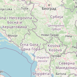
Land Cover Serbia 2022 | Land cover classification for Serbia | Serbia | Sept. 2, 2025 | Republic Geodetic Authority | none |
|
|||
|
OpenStreetMap Land Use Data for Serbia | Land use areas from OpenStreetMap for Serbia | Serbia | Oct. 19, 2024 | OpenStreetMap Contributors | Open Database License |
|
Showing
3
of
3
records