Showing 10 of 81 records (filtered)
Applied filters: 
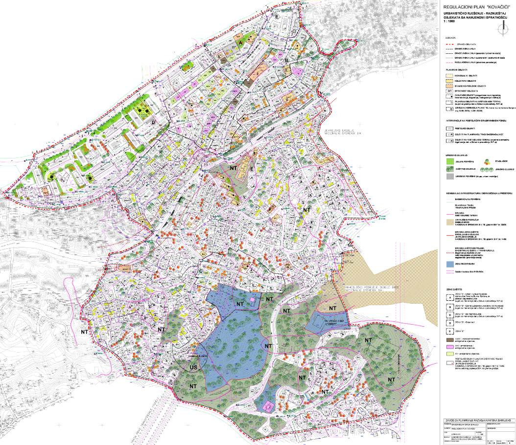
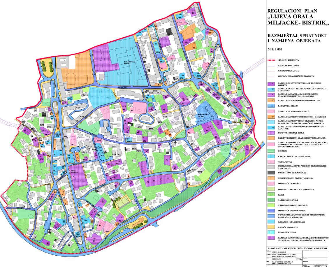
Responsible Party: Sarajevo Canton Development Planning Institute × Topic Category: Land Use / Planning Units × Clear all filters
« first previous Page 7 of 8. next last »
Preview
Title
Abstract
Country
Resource Type
Publication Date
Responsible Party
Topic Categories
Keywords
Access Constraints
Actions
Graphic overview for Regulatory plan "Javorov do"
Regulatory plan "Javorov do" The detailed planning document, the Regulatory Plan "Javorov do", is based on the adopted land use policy, development strategies and … Bosnia and Herzegovina Dataset May 16, 2016 Sarajevo Canton Development Planning Institute other Restrictions
Graphic overview for Regulatory plan "Junakovac"
Regulatory plan "Junakovac" The area of 21.80 ha included in the Plan boundary is located within the boundaries of the Spatial Plan for … Bosnia and Herzegovina Dataset Sept. 20, 2022 Sarajevo Canton Development Planning Institute other Restrictions
Graphic overview for Regulatory plan "Kamenjača"
Regulatory plan "Kamenjača" The detailed planning document, the "Kamenjača" Regulatory Plan, is based on the adopted land use policy, development strategies and programs, … Bosnia and Herzegovina Dataset June 10, 2004 Sarajevo Canton Development Planning Institute other Restrictions
Graphic overview for Regulatory plan "Kanara"
Regulatory plan "Kanara" The area of 16.20 ha, included in the Plan boundary, is located on the northern slopes of Mojmilo Hill and … Bosnia and Herzegovina Dataset July 27, 2016 Sarajevo Canton Development Planning Institute other Restrictions
Graphic overview for Regulatory plan "Karaula"
Regulatory plan "Karaula" The detailed planning document, the "Karaula" Regulatory Plan, is based on the adopted land use policy, development strategies and programs, … Bosnia and Herzegovina Dataset March 30, 2017 Sarajevo Canton Development Planning Institute other Restrictions
Graphic overview for Regulatory plan "Koševo"
Regulatory plan "Koševo" The detailed planning document, the Regulatory Plan "Koševo", is based on the adopted land use policy, development strategies and programs, … Bosnia and Herzegovina Dataset Dec. 15, 2004 Sarajevo Canton Development Planning Institute other Restrictions
Graphic overview for Regulatory plan "Koševsko brdo"
Regulatory plan "Koševsko brdo" The area covered by the Plan boundary, with an area of 47.21 ha, is limited to the east by Alipašina … Bosnia and Herzegovina Dataset July 31, 2013 Sarajevo Canton Development Planning Institute other Restrictions
Graphic overview for Regulatory plan "Kovačići Center"
Regulatory plan "Kovačići Center" The area covered by the Plan boundary, covering an area of 3.65 ha, is bounded by an approximately regular triangular … Bosnia and Herzegovina Dataset Dec. 27, 2011 Sarajevo Canton Development Planning Institute other Restrictions
Graphic overview for Regulatory plan "Kovačići"
Regulatory plan "Kovačići" Detailed planning document Regulatory plan "Kovačići" - is based on the adopted land use policy, development strategies and programs, infrastructure … Bosnia and Herzegovina Dataset May 29, 2013 Sarajevo Canton Development Planning Institute other Restrictions
Graphic overview for Regulatory plan "Left bank of Miljacka - Bistrik"
Regulatory plan "Left bank of Miljacka - Bistrik" The detailed planning document, the Regulatory Plan "Left Bank of the Miljacka River - Bistrik", is based on the adopted … Bosnia and Herzegovina Dataset March 31, 2005 Sarajevo Canton Development Planning Institute other Restrictions
Showing 10 of 81 records (filtered)
« first previous Page 7 of 8. next last »